Pocahontas State Park's mountain bike trails are maintained by a DCR part-time staff and by volunteers and are supported by funds raised through the Friends of Pocahontas. You can help keep these trails in great condition by volunteering your time on trail work days, by donating money to the Trail Fund and also by respecting trail closures which are meant to help protect trails from damage.
Learn Trail BuildingTrails are not natural features - they're designed, built and maintained by skilled volunteers and trail staff. You can learn how to build great sustainable trails by volunteering for our trail work days and signing up for trail classes when offered. Please check our Meetup page for current volunteer opportunities!
|
Important Safety TipsThe best things about Pocahontas Trails is the outdoors experience they offer. To enjoy these trails safely, always let someone know when you'll be riding, only ride trails within your ability level, wear a good fitting helmet and carry a snack, plenty of water, and a cell phone.
|
The IMBA Ride CenterIn 2015, Pocahontas State Park trails and James River Park System trails were designated as an IMBA Bronze level ride center, which we call the Richmond Regional Ride Center.
Find out how you can support the the RRRC. |
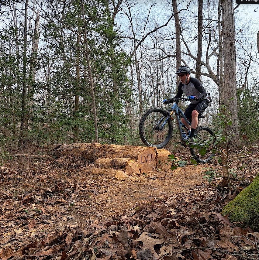
Swift Creek Trail System"Flow town". The Swift Creek trail system is the newest trail system at Pocahontas and contains multiple flow-style and progressive trails. Trails range from beginner level to expert and several also accommodate aMTB riders (hand-cyclists welcome). Here you'll find a small pumptrack and the true beginner level "Gateway trails" are perfect for young riders and are easily accessible from the Loop Forest parking lot off Courthouse Road. More adventurous riders will test their skills on the bermed and gravity focused trails. The trail "Hub" is a good starting point to access all of the Swift Creek trails and is located off Courthouse Rd, Loop FT. Parking fees apply.
The Lakeview TrailsDown-country/backcountry singletrack. Lakeview 1, 2, 3 is a stacked loop system which features flowy hand-built intermediate rated contour singletrack. Each loop contains short interconnecting segments of more difficult trail sections to challenge riders with rock and natural technical features. Lakeview trails are slightly more remote and give great views of Swift Creek Lake. The trailhead for Lakeview begins off the multiuse Powhatan FT.
Gravel fireroads (doubletrack)We love our singletrack trails but there's far more to ride here than just the 40 or so miles in those systems. Pocahontas has more than 50 additional miles of gravel fire roads and dirt doubletrack trails. With so much variety, you can ride all day, all weekend or even all week. The best places to ride are the long loop trails on the north and south sides of the park.
|
Morgan Trail SystemOld-school rooty and twisty singletrack! These trails are the original and officially sanctioned singletrack trails in Pocahontas finished in 1998, lovingly known by many locals as the Green, Blue, and Red trails. Ranging from beginner/intermediate to "expert" level, these trails feature natural hand-cut singletrack, log-overs, natural rock features and multiple creek crossings. The trailhead can be accessed off Crosstic FT.
IMBA’S RULES OF THE TRAIL These guidelines for trail behavior are recognized around the world. IMBA developed the "Rules of the Trail" to promote responsible and courteous conduct on shared-use trails.
1 Ride On Open Trails Only. Respect trail and road closures — ask a land manager for clarification if you are uncertain about the status of a trail. Do not trespass on private land. Obtain permits or other authorization as may be required. Be aware that bicycles are not permitted in areas protected as state or federal Wilderness. 2 Leave No Trace. Be sensitive to the dirt beneath you. Wet and muddy trails are more vulnerable to damage than dry ones. When the trail is soft, consider other riding options. This also means staying on existing trails and not creating new ones. Don't cut switchbacks. Be sure to pack out at least as much as you pack in. 3 Control Your Bicycle. Inattention for even a moment could put yourself and others at risk. Obey all bicycle speed regulations and recommendations, and ride within your limits. 4 Yield to Others. Do your utmost to let your fellow trail users know you're coming -- a friendly greeting or bell ring are good methods. Try to anticipate other trail users as you ride around corners. Bicyclists should yield to all other trail users, unless the trail is clearly signed for bike-only travel. Bicyclists traveling downhill should yield to ones headed uphill, unless the trail is clearly signed for one-way or downhill-only traffic. Strive to make each pass a safe and courteous one. 5 Never Scare Animals. Animals are easily startled by an unannounced approach, a sudden movement or a loud noise. Give animals enough room and time to adjust to you. When passing horses, use special care and follow directions from the horseback riders (ask if uncertain). 6 Plan Ahead. Know your equipment, your ability and the area in which you are riding -- and prepare accordingly. Strive to be self-sufficient: keep your equipment in good repair and carry necessary supplies for changes in weather or other conditions. Always wear a helmet and appropriate safety gear. |
